logo

Draadloos Globaal Maritieme Nood en Veiligheidssysteem

Belangrijkste kenmerken
Merknaam: THUNDSEA
Modelnummer: Slobkous-1000B
Plaats van herkomst: Qingdao
Certificering: CCS
Minimale bestelhoeveelheid: Één reeks
Leveringscapaciteit: 30 reeks per maand
Levertijd: 15 dagen
Betalingsvoorwaarden: L/C, T/T
Standaard Verpakking: Kartondoos

Productoverzicht

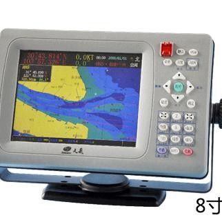
Slobkous-1000B Draadloze hotspot verbinding en Diverse de navigatie Rendabele wijzen van WIFI Hoofdfuncties Het schip met het apparaat kan de informatie, zoals MMSI, naam, positie en type van zich, naar AIS basisstation verzenden. Terwijl theadministration controleert en het schip volgens deze ...

Product aangepaste attributen

Markeren

Draadloos schipveiligheidsbeheerssysteem

,

navigatie veilige terugkeer naar havensysteem

,

van de wifi globaal maritieme nood & veiligheid systeem

model:
Slobkous-1000B (8“) @SPAT-1000B (10“)
Het schermgrootte:
8 inches@10-duim
Resolutie:
800* 600@1024 *768
Toetsenbordinput:
Sneltoets, de sleutel van T9 keyboard@Shortcut, T9-toetsenbord
Mariene grafiek:
√@√
Waypoint:
10000@12000
Teken:
11 soorten en 10000 tekens in total@11-soorten en 10000 tekens in totaal
Route:
20@200
Spoor:
40 spoorlijnen en 20000 het spoorlijnen van spoorpoints@1000 en 10000 spoorpunten voor elke lijn
Getijdenlijst:
√@√
Kompaslijst:
√@√
kalender:
×@√
Havengegevens:
×@√
Schip controlefunctie:
×@√
Plaatsende AIS parameters:
√@√
Frequentiegebied:
156.025MHz~162.025MHz
Werkend frequentiepunt:
2087 (161.975MHz), 2088 (162.025MHz)
Bitrate:
9600 bit/s
Het overbrengen van macht:
2W/6W
Het ontvangen van gevoeligheid:
≤-107dBm
Externe interface:
1*RS232 seriële poort en de periodieke port@1 *USB interface van 1*RS422, 1*RS232-seriële poort en 1
Aanvaardbare gegevens:
GPS en compass@GPS, Beidou en kompas
Algemene Afmeting:
288mm×189mm× 92mm@354mm ×262mm×110mm
Gewicht:
2kg@2.3kg
Voltagewaaier:
Gelijkstroom 9~36V
Nominaal voltage:
GELIJKSTROOM 13.8V/24V
Totale Machtsconsumptie:
≤20W
Werkende temperatuur:
- 20℃~60℃
Productbeschrijving

Slobkous-1000B Draadloze hotspot verbinding en Diverse de navigatie Rendabele wijzen van WIFI


Hoofdfuncties
Het schip met het apparaat kan de informatie, zoals MMSI, naam, positie en type van zich, naar AIS basisstation verzenden. Terwijl theadministration controleert en het schip volgens deze informatie leidt, kan het schip de informatie, zoals navigatiehulp en waarschuwing ontvangen, die aresent door het beleid door andere AIS apparaten. Derhalve veiliger en efficiënter is journeywill.


Eigenschappen

●Wireless hotspot verbinding en WIFI;

●iho-S57 elektronische mariene grafiek, compatibel met riviergrafiek en binnenwatergrafiek (S52-vertoning);

●Various navigatiewijzen met inbegrip van marinechart, elektronisch kompas, AIS radar en Weg;

●Vessel controlefunctie om het spoor te controleren, het verschijnen, het verdwijnen en het vallen uit van zeer belangrijke schepen;

●Multiple hulpfuncties met inbegrip van getijde, havengegevens, kalender en satellietenanalyse;

●Display in Chinees van Chinese schepen.

Indicatoren

Model Slobkous-1000B (8“) Slobkous-1000B (10“)
Vertoning Het schermgrootte 8 duim 10 duim
Resolutie 800*600 1024*768
Toetsenbordinput Sneltoets, T9-toetsenbord Sneltoets, T9-toetsenbord
Mariene grafiek
Navigatiefuncties Waypoint 10000 12000
Teken 11 soorten en 10000 tekens in totaal 11 soorten en 10000 tekens in totaal
Route 20 200
Spoor 40 spoorlijnen en 20000 spoorpunten 1000 spoorlijnen en 10000 spoorpunten voor elke lijn
Extra functies Getijdenlijst
Kompaslijst
Tijdschema ×
Havengegevens ×
Schip controlefunctie ×
Plaatsende AIS parameters
AIS prestatiesparameters Frequentiegebied 156.025MHz~162.025MHz
Werkend frequentiepunt 2087 (161.975MHz), 2088 (162.025MHz)
Bitrate 9600 bit/s
Het overbrengen van macht 2W/6W
Het ontvangen van gevoeligheid ≤-107dBm
Interface Externe interface 1*RS232 seriële poort en 1*RS422-seriële poort 1*USB interface, 1*RS232-seriële poort en 1*RS422-seriële poort
Aanvaardbare gegevens GPS en kompas GPS, Beidou en kompas
Algemene afmeting 288mm×189mm×92mm 354mm×262mm×110mm
Gewicht 2kg 2.3kg
Machtsinput Voltagewaaier Gelijkstroom 9~36V
Nominaal voltage GELIJKSTROOM 13.8V/24V
Totale machtsconsumptie ≤20W
Werkende temperatuur - 20℃~60℃


Toepassingen
Dit product is op AIS (Automatisch Identificatiesysteem), het systeem van het havenluchtverkeersbeheer, het beheersysteem van het visserijschip, enz. van toepassing

Draadloos Globaal Maritieme Nood en Veiligheidssysteem 0

Gerelateerde producten
Kwaliteit Globaal de Maritieme Nood en de Veiligheidssysteem van de Zoekenredding fabriek

Globaal de Maritieme Nood en de Veiligheidssysteem van de Zoekenredding

Search and rescue treasure VSA8 High Receiving Sensitivity Water-proof Antenna Specifications Battery Lithium battery,9V/1.5AH,8 years life Performance time >24h@-20℃ Antenna Vertical monopole Programming interface Two-way infrared.940nm LCD 128*64,Lattice Activation way Manual/By water Agreement support MSG1.MSG14 Water-proof properties 5m/10mins Size 90mm×49mm×30mm,116g Working temp -20℃~50℃ Storage temp -40℃~70℃ AIS Transmitte ◆ Output frequency: 161.975 MHz, 162.025 MHz ◆
Kwaliteit Van de manchet Globaal Maritieme Nood & Veiligheid Systeem fabriek

Van de manchet Globaal Maritieme Nood & Veiligheid Systeem

Wristband Beacon VSA7 Wristband Antenna MSG1,MSG14 Agreement support Specifications Battey Lithium battey,4 years life Performance time >12h@-20℃ Antenna Wristband Activation modes Manual Agreement support MSG1,MSG14 Water-proof propeties 5m,10 minutes Size and Weight Dia.50mm*Thickness 16mm,62g Working temp -20℃~50℃ Storage temp -40℃~70℃ AIS Transmitte ◆Output frequency: 161.975MHz, 162.025MHz ◆ Output power: 1W (30dBm) ± 1.5dB ◆ Data rate: 9600bps ◆ Modulation bandwidth:
Kwaliteit AIS ingebedde Transpondergmdss GMSK modulatie de verwerking van platform en time-division veelvoudig adres fabriek

AIS ingebedde Transpondergmdss GMSK modulatie de verwerking van platform en time-division veelvoudig adres

AIS Transponder GMSK modulation embedded processing platform and time-division multiple address Function In case that a ship gets into danger, AIS SART can send the information about the positions of the crew to AIS device, so as to greatly improve the survival ratio of them. Feature GMSK modulation, embedded processing platform and time-division multiple address are adopted. Specifications Frequency range 161.975MHz,162.025MHz Transmitting power 2W(33dBm)±1.5dB Modulation
Kwaliteit De prestaties High-power zender Met hoge weerstand en waterdichte van het netwerk Plaatsende Instrument VAS9 fabriek

De prestaties High-power zender Met hoge weerstand en waterdichte van het netwerk Plaatsende Instrument VAS9

Network Positioning Instrument VAS9 High strength and waterproof performance High-power transmitter Specifications Operate time ≥360h(1t/min) Perate frequency 161.975MHz/162.025MHz Output power 38.5dBm(7W)±1.5dBm Bit rate 9600b/s±50ppm(GMSK) Operating temp -20℃~55℃ Electrical interface infrared programming interface Built-in battery 7.4V lithium-ion battery Size 23.5cm×7.5cm,long antenna 110cm,short antenna 40cm Weight 415g Antenna external VHF antenna Communication distance
Kwaliteit (SART) esr-06 goede EMC rijpe technologie en de betrouwbare consumptie van de prestaties Lagere macht GMDSS fabriek

(SART) esr-06 goede EMC rijpe technologie en de betrouwbare consumptie van de prestaties Lagere macht GMDSS

(SART)ESR-06 good EMC mature technology and reliable performance Lower power consumption Main functions ● It is capable of detecting the pulse action through the navigation radar installed on a search and rescue vessel or a helicopter. The signal from SART can indicate the exact position V of the SART on the fluorescent screen of the navigation radar of the search and rescue vessel or the helicopter; ● The survior who holds an SART or a vessel or boat in distress where an
Kwaliteit VPL8 GPS Compact in groottelicht in gewicht Ingebouwd GPS voor snelle en nauwkeurige positionin GMDSS fabriek

VPL8 GPS Compact in groottelicht in gewicht Ingebouwd GPS voor snelle en nauwkeurige positionin GMDSS

VPL8 GPS Compact in size light in weight Built-in GPS for fast and accurate positionin GMDSS Function Compact in size, light in weight, floating on water; Built-in GPS for fast and accurate positioning; Outdoor LCD screen for displaying coordinates and other information; Super bright LED flashlight; Comprehensive fault diagnosis functions Specification 406MHz satellite signal transmitter Output frequency 406.040MHz±1kHz Battery pack Lithium battery,warranty:8 years Output
Kwaliteit VEP8 lage onderhoudskosten voor batterij en hydrostatische releaser Lage verdwaalde ow harmonische lage macht-consumptie fabriek

VEP8 lage onderhoudskosten voor batterij en hydrostatische releaser Lage verdwaalde ow harmonische lage macht-consumptie

VEP8 Low maintenance cost for battery and hydrostatic releaser Low stray ow harmonic low power-consumption Function VEP8 can be activated automatically or manually when ships in distress. Then the emergency signal of 406MHz for help will be transmitted and forward to the search and rescue center by satellite. The search and rescue center will carry out the emergency rescue plan according to the received signal. Features ◆Low maintenance cost for battery and hydrostatic
Kwaliteit China maakte tot spgt-1000 Rendabele AIS Revicer 156.025MHz~162.025MHz voor Diverse Boten GMDSS fabriek

China maakte tot spgt-1000 Rendabele AIS Revicer 156.025MHz~162.025MHz voor Diverse Boten GMDSS

China made SPGT-1000 Cost-effective AIS Revicer 156.025MHz~162.025MHz for Various Boats Main functions ●Information receiving: It is capable of receiving both static and dynamic information from AIS CLASS A, AIS CLASS B, AIS base station, AIS navigation aids, AIS SART and search and rescue helicopters, as well as the UTC time and position information from GPS. ●Information processing: It is capable of outputting AIS and GPS information received in the data format specified in